Outsight introduces 3D Lidar simulator

New tool allows customers to work out what kit and coverage - and cost - they require
By Adam Hill November 17, 2022 Read time: 2 mins
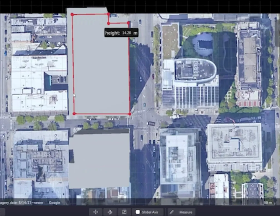
Users can insert their own scenes as a background by using built-in tools for modifying 3D shapes

Lidar specialist Outsight has launched a 3D Lidar simulation tool to help customers answer fundamental questions about deployment.

Deciding which and how many Lidars to use, and working out the best locations for them in terms of height, position and orientation, are among the issues the new tool is designed to overcome.

Users can make up their own simulation and environment to choose the best setting for achieving your performance and functionality goals, anticipating performance depending on each set-up and use case.  .

Outsight sought feedback on its beta version "from more than 300 early customers from various contexts, applications and countries".

It points out there is no need to install any software - users simply connect to their Outsight Cloud account, or request access if they do not already have one. 

Users can browse a list of compatible Lidars and select the right model or combination of models from different manufacturers (e.g. 360º FoV, Narrow Field of View, Dome).

You can find the optimal Lidar coverage by testing different options and coverage levels, establishing the best trade-off between performance, hardware cost and complexity, Outsight says.

It is possible to insert your own scenes as a background by using built-in tools for modifying 3D shapes.

For more information on companies in this article

Related Content

  • Certification for Parifex 3D Lidar speed camera trio
    April 21, 2023
    French firm's Nano-Cam, Nomad & Double-Side Vigie all approved for use
  • Ertico: calling all (European) cities
    April 28, 2022
    Host city of ITS European Congresses in 2025 & 2026, and World Congress 2027, all up for grabs
  • PTV Group and Inrix partner on smart cities
    September 9, 2014
    PTV Group and Inrix are to collaborate on smart city solutions that will use big data and demand-based modelling software to solve urban mobility problems worldwide. As part of a multi-year global agreement, PTV Group is integrating Inrix XD Traffic into PTV Optima, its state-of-the-art tool for traffic prediction. With real-time information on traffic speeds and travel times for more than four million miles of roads in 40 countries, Inrix XD Traffic improves accuracy and offers detailed traffic informat
  • Homeland Security to launch smart cities pilot in St. Louis
    September 4, 2019
    The Department of Homeland Security (DHS) Science and Technology Directorate (S&T) is to launch a smart cities technology pilot in the US city of St. Louis, Missouri. DHS S&T will work with the city and the Open Geospatial Consortium to design and test smart city interoperability reference architecture (SCIRA) as a framework that integrates Internet of Things sensors for public safety applications. Lyda Krewson, mayor of St. Louis, says: “Community level application of existing technologies is essential