
Seoul Robotics opens doors of perception

SENSR-I software can capture actionable data on movement of people and vehicles
March 25, 2022 Read time: 1 min
SENSR-I can simultaneously track the precise movements of people, vehicles and bicycles over expansive areas, says Seoul Robotics

Seoul Robotics has introduced an infrastructure-based version of its SENSR 3D perception software.

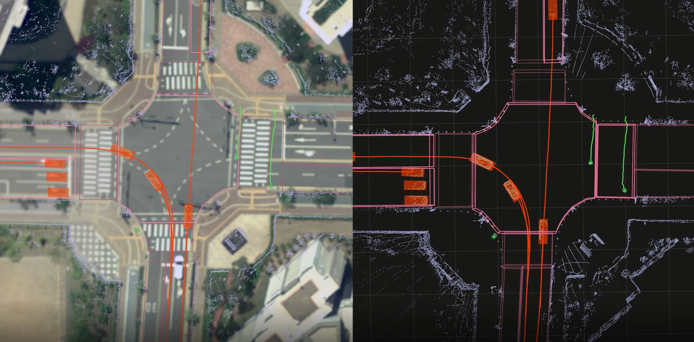
The new product, SENSR-I, processes data captured by 3D sensors to provide high-resolution environmental insights, enabling customers to see how people and vehicles move through large spaces. 

It supports anything from central processing to edge computing and is sensor- and hardware-agnostic, the company says.

When applied to 3D sensors on static infrastructure (indoors and outdoors), SENSR-I can precisely track within an error of 4cm.

“Until now, 2D cameras have been the only accessible, affordable solution, but that is no longer the case," says Jerone Floor, VP of products and solutions at Seoul Robotics.

"Indisputably, 3D systems enable organisations to get deeper, more actionable data. SENSR-I changes the game with its ability to simultaneously track the precise movements of people, vehicles and bicycles over expansive areas – unlocking unprecedented insights that can transform operations in ways never before possible."

3D analytics uses non-biometric data "with more robust 3D vision that is able to accurately detect object movement beyond what is visible from a single perspective, as well as track a single object across multiple sensors", Seoul adds.

The Korean government invested $12m in Seoul Robotics last year.

For more information on companies in this article

Related Content

  • Digital twin for Helsinki
    November 22, 2022
    Finnish capital uses intelligence from Xyzt.ai and Geo Mobility to improve urban mobility
  • Bluetooth and Wi-Fi offer new options for travel time measurements
    November 20, 2013
    New trials show Bluetooth and Wi-Fi signals can be reliably used for measuring travel times and at a lower cost than an ANPR system, but which is the better proposition depends on many factors. Measuring travel times has traditionally relied automatic number plate (or licence plate) recognition (ANPR/ALPR) cameras capturing the progress of vehicles travelling along a pre-defined route. Such systems also have the benefit of being able to count passing traffic and have become a vital tool in dealing with c
  • States take control with Ubicquia
    September 30, 2022
    Smart cities and connectivity platforms distributed by EPI and MAG in Florida and Carolinas
  • GridMatrix goes back to the future in New York City
    September 25, 2023
    Legacy traffic management infrastructure doesn’t have to be a marker of the past: software upgrades can bring it into the present in a cost-effective and timely way, says Gordon Feller