
Toshiba upgrades solid-state Lidar

Toshiba's Lidar operates in a variety of lighting and weather conditions to 200m
By Ben Spencer July 6, 2021 Read time: 2 mins
Toshiba says its Lidar can monitor snow cover or objects in the road (© Oskari Porkka | Dreamstime.com)

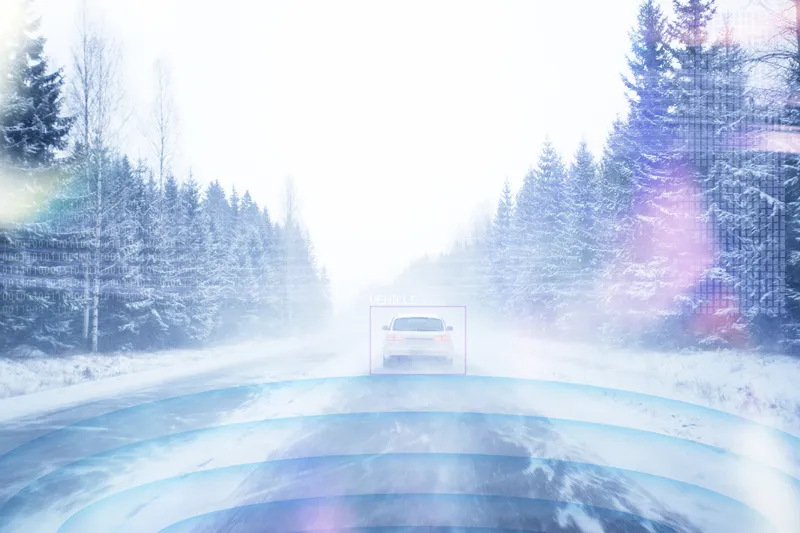
Toshiba has upgraded its solid-state Lidar which it says maintains a maximum detection range of 200m and will advance progress in autonomous driving. 

The company is expanding the application to monitor transportation infrastructure, in such areas as early detection of road subsidence or landslides, snow cover or falls of objects onto roads.

Akihide Sai, senior research scientist at Toshiba’s corporate research & development centre, says: “We have secured technologies essential for a compact, high-resolution, long-range solid-state Lidar that is robust and simple to install."

"We anticipate demand for such a versatile technology in both the autonomous driving and transportation infrastructure monitoring markets.”

Current monitoring of transportation infrastructure relies on cameras, but Toshiba points out their performance is degraded by low light and bad weather.

The new Lidar is expected to realise clear, long-distance, robust 3D scanning and object detection in a variety of lighting and weather conditions. 

Toshiba achieved a compact Lidar through upgrades to its silicon photo-multiplier (SiPM), a light-receiving chip that consists of light-receiving cells controlled by transistors. 

The new chip has a smaller transistor module, and eliminates the buffer layer that protected the transistors with newly developed insulating trenches between the transistors and the light-receiving cells, the firm adds. 

The potential issue of low light-sensitivity from using smaller transistors was solved with the addition of a high-withstand voltage section to raise the voltage input to the light-receiving cell. 

According to Toshiba, these innovations have reduced the size of the SiPM by 75% while enhancing its light sensitivity by 50% against the July 2020 previous model.

More SiPM can now be arrayed in the same package, which the company insists boosts resolution to 1,200 x 80 pixels, a four-times improvement.

Toshiba is to continue to support safer transportation by promoting its LiDAR technologies for autonomous driving and transportation infrastructure monitoring. Continued R&D is expected to further advance the Lidar’s detection range and image resolution. 

For more information on companies in this article

Related Content

  • Transportation applications move to machine vision’s mainstream
    June 11, 2015
    The adaptation of machine vision to transport applications continues apace. That the machine vision industry is taking traffic installations seriously is evident by the amount of hardware and software products tailor-made for ITS applications that are now available on the market. A good example comes from US-based Gridsmart Technologies which has developed a single wire fisheye camera that provides a horizon to horizon view for use at intersections. Not only does the single camera replace four or more in a
  • US updates ITS strategy for Connected Vehicle deployment
    March 16, 2015
    Jon Masters looks at the USDOT’s new ITS Strategic Plan for the next five years. Emphasis and direction for the next five years of Government led ITS research in the United States has been framed within a new ITS Strategic Plan. The US Department for Transportation’s (USDOT) ITS Joint Program Office (JPO) published the report at the tail end of 2014 after concluding a two-year ITS industry consultation process. The Plan identifies a vision to transform the way society moves and the ITS JPO’s aim of advancin
  • Velodyne applies AI to traffic monitoring 
    May 18, 2021
    Lidar-based AI traffic solution installed at multiple intersections in New Brunswick, New Jersey
  • Growth in commercial drones to bring multiple benefits but also new risks
    September 20, 2016
    A new report from aviation insurer Allianz Global Corporate & Specialty (AGCS), Rise of the Drones: Managing the Unique Risks Associated with Unmanned Aircraft Systems, indicates that numbers of unmanned aircraft systems (UAS) to surge as they become smaller and cheaper. Whether used commercially for industrial inspections, aerial photography, border patrol, emergency deliveries and crop surveys or recreationally by millions, drones or unmanned aircraft systems (UAS) have the potential to become a multi-