
Browsing welcome in Here's Lidar library

Company says it hopes to decrease the costs associated with data collection surveys 
By Ben Spencer January 18, 2022 Read time: 1 min
Here Lidar Data allows agencies to access geospatial data for virtualised asset management and road network planning (image credit: Here Technologies)

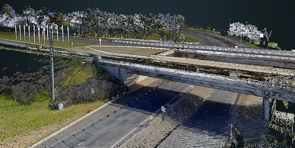
Here Technologies' global library of three-dimensional Lidar data (Light Detection and Ranging) – which captures roadways and their surroundings – is now available on its platform.

Here says Here Lidar Data enables users to create a 'digital twin' representation of reality with the identification, classification and localisation of objects within +/- 2 centimetres of relative accuracy within the Lidar point clouds.

According to Here, the Lidar data supports a colourised feature that infuses each point with an RGB (red, green blue) value for improved visual contrast of real-world objects within the point cloud.

Here Lidar Data allows the public sector departments and transportation agencies to access highly precise geospatial data for virtualised infrastructure asset management, road network planning, traffic congestion analysis and federal reporting requirements.

Here chief product officer Jørgen Behrens says: "Users can request Here Lidar Data as a Service, or they can access the company’s global library of 3D point clouds via the Here Platform. Our goal is to help decrease the time and cost associated with commissioning traditional data collection surveys.”
 

For more information on companies in this article

Related Content

  • Qualcomm: How Connected Driving Will Reduce Emissions in the EU
    September 14, 2023
    In an era marked by climate change and an urgent need for greener mobility solutions, the advent of connected driving has emerged as a promising frontier in the realm of transportation.
  • GridMatrix maximises power of existing infrastructure
    August 5, 2023

    GridMatrix’s breakthrough software platform for multimodal data collection and analytics is revolutionising transportation planning and decision making across the US. 

    Powered by artificial intelligence and combining the latest advances in cloud computing, machine learning and advanced sensing, GridMatrix’s platform is deployed in New York City on the world’s busiest bridges and tunnels, trusted by multiple state departments of transportation, and in a fast-growing number of American towns and cities. 

  • Neology enters National Highways framework 
    February 15, 2022
    Appointment allows firm to provide solutions such as average speed enforcement
  • Cloud computing technology benefits GIS
    July 17, 2012
    Geographic Information Systems are a relatively late adopter of cloud computing,but the benefits of host services for geospatial data and analysis are becoming clear. Jason Barnes reports Both the concept and the reality of cloud computing have been around for some time. More and more industry sectors are entrusting external service providers with the provision of their computing services via the internet. However, the Geographic Information System (GIS) industry has been slow to embrace the trend. This is