
Road data role for Sydney buses

Asset AI scheme sees 32 public transport buses equipped with a camera and sensor
By David Arminas July 22, 2022 Read time: 2 mins
Downtown Sydney: all aboard the AI data bus (© Bundit Minramun | Dreamstime.com)

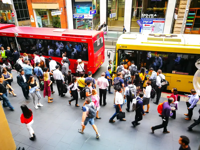
New South Wales is trialling the use of buses equipped with sensors to predict the rate of road deterioration in order to prioritise road maintenance.

Under the US$1.97 million scheme, called Asset AI, currently 32 public transport buses in the Greater Sydney area each have a camera and sensor.

The technology can be combined with local weather observations to predict the rate of deterioration, according to a statement by the New South Wales government.

The joint initiative by Transport for NSW and the Roads and Transport Directorate includes the technology being mounted onto garbage trucks.

Sam Farraway, minister for regional transport and roads, also said data is being collected outside of the city by a utility vehicle mounted with cameras scanning 100km of rural roads across the state. “We will have it out collecting data along the Great Western Highway between Lithgow and Bathurst, the Sturt Highway near Wagga Wagga and around Spring Ridge in the Upper Hunter.”

Natalie Ward, minister for metropolitan roads, said technology is revolutionising road maintenance across the state. “It’s a brilliant use of resources already on our roads. Mounting cameras and sensors onto vehicles with regular routes, like garbage trucks and public transport buses, ensures road defects are captured incidentally, including those un-reported by residents,” she said.

The NSW government says it is delivering the largest transport infrastructure programme in Australia, a  US$52.15 billion of investment over four years for projects including Sydney Metro, light rail, motorways and road upgrades that will shape the state’s cities, centres and communities for generations to come.

For more information on companies in this article

Related Content

  • Vaisala enriches road condition data use 
    May 20, 2021
    Solution with Yotta means engineers can collect geospatial video data from network
  • Qatar invests $70 billion to pave the way to world beating transportation
    July 26, 2013
    Eng. Zeina Nazer looks at what Qatar’s recently-announced investment in transport infrastructure will mean on the ground. Qatar is experiencing a rapid economic and industrial growth. This growth is characterised by a rapid population increase and by the urgent need towards the development of both infrastructure projects and major transport projects. In order to handle this rate of development within Qatar, Public Works Authority (Ashghal) is developing a fully-integrated multimodal transportation system in
  • Missouri’s smart solution for rural road monitoring
    July 7, 2017
    David Crawford sees how Missouri is using commercially available information to rapidly improve monitoring and driver information on rural highways. Missouri is a predominantly rural state with the second largest number of farms in the country and agriculture the main occupation in 97 of its 114 counties. US statistics starkly reveal how road accidents in rural areas tend to be more serious than in urban regions and of the 32,000 US motorists killed each year, 54% die on roads in rural areas even though onl
  • Rural roads ‘critical to moving people and goods’
    June 25, 2015
    In his opening statement at the US Subcommittee on Highways and Transit Hearing on Meeting the Transportation Needs of Rural America, chairman Sam Graves said that even today, 71 per cent of all lane-miles of public roads and 73 per cent of all of the nation's bridges are located in rural areas. In his home state of Missouri, the role of rural roads is even more pronounced: 82 per cent of the public roads and 81 per cent of bridges are in rural areas, and these roads carry over 40 per cent of all travel in