
Utah intersection Lidar traffic management from Seoul Robotics

Firm says signals at Salt Lake City installation are first to be Lidar-controlled in US
By Adam Hill July 8, 2024 Read time: 2 mins
Lidar sensors are at each corner of the intersection, and create a digital twin (image: Seoul Robotics)

Seoul Robotics has deployed its Lidar-powered traffic signal system in Utah, US.

Installed at the junction of State Street and 5900 South in Murray, Salt Lake City, this is the first intersection in the US where traffic signals are controlled directly by Lidar technology, Seoul Robotics says.

The Utah Department of Transportation (UDoT) wanted advanced sensor technology that can detect, count and track vehicles and other road users under any weather conditions. 

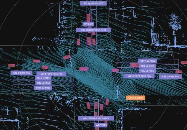
The installation is powered by Seoul Robotics' 3D Perception engine, housed in a compact edge device, with Lidar sensors at each corner of the intersection, which create a digital twin which feeds data to optimise traffic flow and reduces congestion.

Local distributor Gades Sales Company has ensured the system is integrated into local infrastructure, while Blue Band's software translates the data from the 3D Perception Engine into signal commands compatible with existing traffic controllers. 

Seoul Robotics says the solution "mounts directly onto existing infrastructure without significant road work and infrastructure changes". 

Traffic management features include precise stop-bar detection, advanced vehicle detection up to 300 feet from the stop bar, and red-light running. The system has a vehicle counting accuracy of 99.8% at the stop bar, the firm says.

 "Since its installation, our Lidar-based traffic management system has consistently demonstrated excellent detection and tracking of objects, ensuring reliable performance across all weather conditions," says Lee Han-bin, CEO of Seoul Robotics.

"This technology not only meets but exceeds the demands of modern traffic systems."

As well as vehicle flow, the system is designed to accurately count and monitor vulnerable road users, such as pedestrians and cyclists at crosswalks and kerbsides.

Seoul Robotics says deep learning and 3D computer vision ensure that all perceived objects are accurately tracked and classified in real time, enhancing safety and traffic flow across multiple road user types.

For more information on companies in this article

Related Content

  • On a WIM – a global view of weigh in motion
    May 25, 2016
    Q-Free’s Andrew Lees looks at regional characteristics and technology trends in the global Weigh-In-Motion market. The principles of Weigh-In-Motion (WIM) are well established. Data derived from vehicles passing over in-ground sensors can be interpreted for vehicle classification (axle counts and spacing) and positive identification (especially when linked to image capture) applications as well as to derive individual axle and gross vehicle weight (GVW).
  • AWS finds new solutions
    December 8, 2021
    Forward-thinking public agencies are turning to a new breed of solutions provider to address current traveller needs. They work with system integrators, independent software vendors, and consultants to innovate using Amazon Web Services (AWS) to improve traffic safety, construction project management, analytics and reporting, and secure identification. Phil Silver, a state and local government transportation leader at AWS, provides examples of how builders on AWS are transforming transport using technology
  • Fare game with Cubic's FEnX
    February 28, 2025
    New gate can accurately detect, record and flag fare evasion as it’s happening
  • Smart Spanish city trials cell-based traffic management
    November 7, 2013
    David Crawford reports on an urban electronic nervous system. The northern Spanish city of Santander – historically a port - is now an emerging technology showcase attracting global attention as a prototype for a medium-sized smart city of the future. In a move to determine the optimal use of available data, it is creating a de-facto experimental laboratory for sensor and mobile phone-based urban traffic management and environmental monitoring innovations.