UK company Traffic Technology has supplied Surrey County Council with its SDR (speed detection radar) above ground vehicle classifier as part of the Drive Smart campaign, a partnership initiative involving Surrey County Council and Surrey Police that targets anti-social driving. Speeding was highlighted as the issue of greatest concern to local residents so all eleven boroughs or districts in Surrey have been supplied with at least two SDRs.
UK company 561 Traffic Technology has supplied 4241 Surrey County Council with its SDR (speed detection radar) above ground vehicle classifier as part of the Drive Smart campaign, a partnership initiative involving Surrey County Council and Surrey Police that targets anti-social driving. Speeding was highlighted as the issue of greatest concern to local residents so all eleven boroughs or districts in Surrey have been supplied with at least two SDRs.
“The SDR is used as a vital tool to either prove or disprove a concern of speed,” said Michael Pritchard, casualty reduction officer for Spelthorne Borough. “Not only will it reveal if there is a speeding issue, but the data can be studied to discover the exact problem times, thus saving many hours at the side of the road and wasting time enforcing speed when there is merely a perceived problem.”
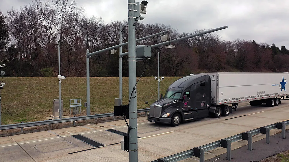
The Traffic Technology SDR uses the latest radar technology to accurately detect each vehicle passing the invisible sensor zone, and provides accurate count, classification and speed data for each direction of a bi-directional single carriageway. All the SDR units used by the county council have been upgraded with the latest Newcomm software which enables data to be downloaded via Bluetooth or GPRS to the online WebReporter software and output in a range of formats to suit their needs.
Data from the SDRs is shared with the council, which maintains a speed management plan for each area, and contains SDR data, both historic and current, for each road on the plan. These include roads where there is a history of fatal and serious injury accidents, roads where there are proven speed issues and roads where there is a pattern of damage only collisions. The data forms a valuable part of the plan especially when enforcement strategies are planned and permanent engineering measures are being considered.
“The SDR was designed to meet the need for accurate and reliable non-intrusive traffic monitoring,” says Richard Toomey, managing director of Traffic Technology. “As it needs no in road sensors, it is quick and easy to deploy for temporary speed monitoring applications.”
“The SDR is used as a vital tool to either prove or disprove a concern of speed,” said Michael Pritchard, casualty reduction officer for Spelthorne Borough. “Not only will it reveal if there is a speeding issue, but the data can be studied to discover the exact problem times, thus saving many hours at the side of the road and wasting time enforcing speed when there is merely a perceived problem.”
The Traffic Technology SDR uses the latest radar technology to accurately detect each vehicle passing the invisible sensor zone, and provides accurate count, classification and speed data for each direction of a bi-directional single carriageway. All the SDR units used by the county council have been upgraded with the latest Newcomm software which enables data to be downloaded via Bluetooth or GPRS to the online WebReporter software and output in a range of formats to suit their needs.
Data from the SDRs is shared with the council, which maintains a speed management plan for each area, and contains SDR data, both historic and current, for each road on the plan. These include roads where there is a history of fatal and serious injury accidents, roads where there are proven speed issues and roads where there is a pattern of damage only collisions. The data forms a valuable part of the plan especially when enforcement strategies are planned and permanent engineering measures are being considered.
“The SDR was designed to meet the need for accurate and reliable non-intrusive traffic monitoring,” says Richard Toomey, managing director of Traffic Technology. “As it needs no in road sensors, it is quick and easy to deploy for temporary speed monitoring applications.”