Looking 15 minutes into the future

Fourth annual Traffic4cast congestion prediction competition seeks AI expertise
By Alan Dron August 11, 2022 Read time: 2 mins
Here data for the challenge is based on more than 100 billion GPS probe points (image credit: IARAI)

Members of the machine learning community are being challenged to use the latest AI methods to model and predict future traffic congestion levels and vehicle speeds across three major cities – London, Madrid and Melbourne – in the fourth annual Traffic4cast competition

The challenge has been set by the Institute of Advanced Research in Artificial Intelligence (IARAI), an independent global machine learning research institute, together with location data specialist Here Technologies. 

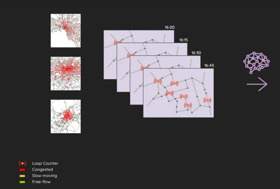
The event’s core challenge sees participants asked to predict congestion level classes (red/yellow/green) for the entire road graph 15 minutes into the future, using only the past hour of traffic loop counter data. 

In the extended challenge, contestants have to predict the average speeds on each road segment of the graph 15 minutes into the future, again, using only the previous hour’s traffic loop counter data.

Here provides the participants with traffic film clips based on two years of real-world data for the three cities.

The clips were created using Here data based on more than 100 billion GPS probe points from a large fleet of vehicles. 

The data is fully anonymised and transformed into movie clips that depict traffic over time, including morning, evening and rush hour traffic events. 

The competition’s aim is to reduce the barriers for using readily available, public loop counter data to predict future traffic state of entire cities. 

IARAI says that the Traffic4cast competition is unique in merging AI with real-world datasets and traffic research to advance the understanding of complex traffic dynamics and systems. 

Winners will receive prizes at NeurIPS 2022, the leading AI conference.
   
The three top-placed entries in the core challenge will receive vouchers or cash worth, respectively, €5,000, €3,000 and €2,000. All three teams will also receive one free NeurIPS 2022 conference registration.

Similar prizes will also be available for the top-placed three teams in the extended challenge. 
 
Submissions are due by October 15.

For more information on companies in this article

Related Content

  • Getting connected with Wejo
    July 1, 2022
    New cloud-based platform allows researchers to run mobility studies using CV data
  • Asking drivers what information they need: radical but effective
    March 19, 2014
    When Texas A&M Transportation Institute was asked to devise a temporary traveller information system for work zones, it started by asking drivers what they need. Robert Brydia explains the thinking, implementation and results. US Interstate 35 (I-35) runs roughly north–south originating in Laredo, Texas and ends 1,500 miles away in Duluth, Minnesota having passed through Oklahoma, Kansas, Missouri and Iowa. Within Texas the I-35 splits into I-35E and I-35W passing through Dallas and Fort Worth respectiv
  • Inertial sensors dramatically improve GNSS for ITS applications
    January 18, 2012
    Phil Harris, Thales UK, on how fused sensor data can significantly enhance GNSS-based positioning systems' performance in urban areas. Global Navigation Satellite System (GNSS)-based positioning is unique among available positioning technology due to its universal coverage and low equipment cost. By measuring the distances between an unknown position (such as a vehicle), and at least three known positions (GPS satellites), the unknown position can be calculated in three dimensions (latitude, longitude, and
  • Peek highlights traffic management and adaptive control
    June 2, 2015
    Peek Traffic is showcasing at this year’s ITS America Annual Meeting, its recently announced Advanced Traffic Management System (ATMS) software called Spinnaker. Spinnaker, is a true web-based application using the latest web technologies, allowing it to be viewed through a web browser from a number of different operating systems and computing devices such as Windows, OSX, Android, iOS and Linux. The system is scalable and modular, allowing traffic control centers to monitor multiple subsystems such as I