
Looking 15 minutes into the future

Fourth annual Traffic4cast congestion prediction competition seeks AI expertise
By Alan Dron August 11, 2022 Read time: 2 mins
Here data for the challenge is based on more than 100 billion GPS probe points (image credit: IARAI)

Members of the machine learning community are being challenged to use the latest AI methods to model and predict future traffic congestion levels and vehicle speeds across three major cities – London, Madrid and Melbourne – in the fourth annual Traffic4cast competition

The challenge has been set by the Institute of Advanced Research in Artificial Intelligence (IARAI), an independent global machine learning research institute, together with location data specialist Here Technologies. 

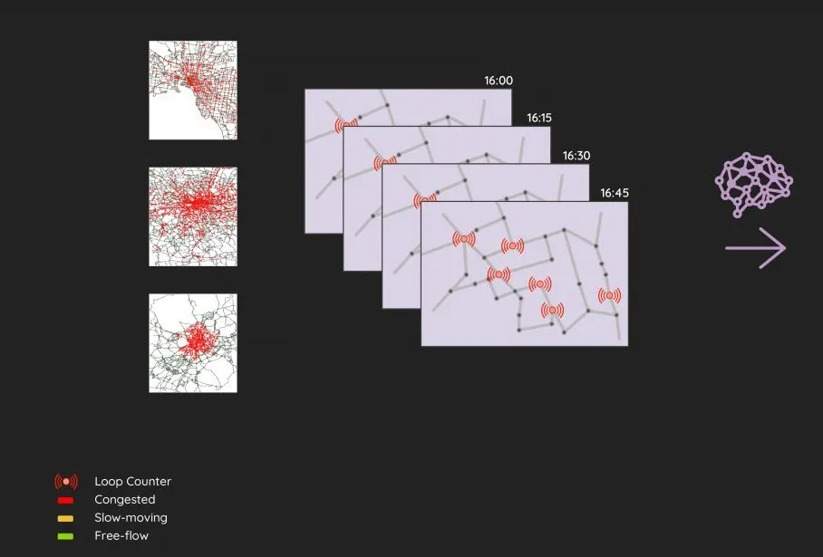
The event’s core challenge sees participants asked to predict congestion level classes (red/yellow/green) for the entire road graph 15 minutes into the future, using only the past hour of traffic loop counter data. 

In the extended challenge, contestants have to predict the average speeds on each road segment of the graph 15 minutes into the future, again, using only the previous hour’s traffic loop counter data.

Here provides the participants with traffic film clips based on two years of real-world data for the three cities.

The clips were created using Here data based on more than 100 billion GPS probe points from a large fleet of vehicles. 

The data is fully anonymised and transformed into movie clips that depict traffic over time, including morning, evening and rush hour traffic events. 

The competition’s aim is to reduce the barriers for using readily available, public loop counter data to predict future traffic state of entire cities. 

IARAI says that the Traffic4cast competition is unique in merging AI with real-world datasets and traffic research to advance the understanding of complex traffic dynamics and systems. 

Winners will receive prizes at NeurIPS 2022, the leading AI conference.
   
The three top-placed entries in the core challenge will receive vouchers or cash worth, respectively, €5,000, €3,000 and €2,000. All three teams will also receive one free NeurIPS 2022 conference registration.

Similar prizes will also be available for the top-placed three teams in the extended challenge. 
 
Submissions are due by October 15.

For more information on companies in this article

Related Content

  • Do satellites provide a heavenly view of tolling’s future?
    December 16, 2014
    Satellite-based tolling opens up new options for authorities and can be integrated with DSRC systems as David Crawford discovers. As the proud custodian of the European Union (EU)’s longest road network covered by a single (truck) charging scheme – and the only one to include all major roads - Slovakia has become the continent’s poster-nation for the virtues of GNSS/CN (Global Navigation Satellite System/Cellular Network)-based tolling. It is also proved to be a very fast implementer. Speaking at the 2014 I
  • TRL announces new student award initiative
    September 22, 2016
    The UK Transport Research Laboratory (TRL) has launched the TRL Student Award, which aims to tap into the creative skills of today’s younger generation in the UAE in order to help solve practical, real life problems while also helping the region in its move towards more growth and development. The initiative will award some of the region’s top student minds for their proposals of innovative and sustainable transport solutions in a special awards ceremony on the sidelines of Gulf Traffic 2016, which will
  • Juniper Research: traffic tech will save cities $277bn
    March 2, 2021
    V2X is critical to enhancing smart traffic management services, Juniper Research finds
  • High-res traffic data provides planners with the big picture
    November 5, 2015
    Road authorities have a lot to gain from high-resolution traffic data, argues Pravin Varaiya. Traffic engineers have traditionally been forced to operate with limited data regarding the performance of their arterials. Traffic studies are often commissioned once every three years, over a few days, to get an updated estimate of utilization.