
US state DoTs in path of Hurricane Idalia take emergency measures

Florida and Georgia are braced for impact of Category 3 storm with 125mph winds
By Adam Hill August 30, 2023 Read time: 2 mins
Image shows Hurricane Irma heading towards Florida in 2017 (© Lavizzara | Dreamstime.com)

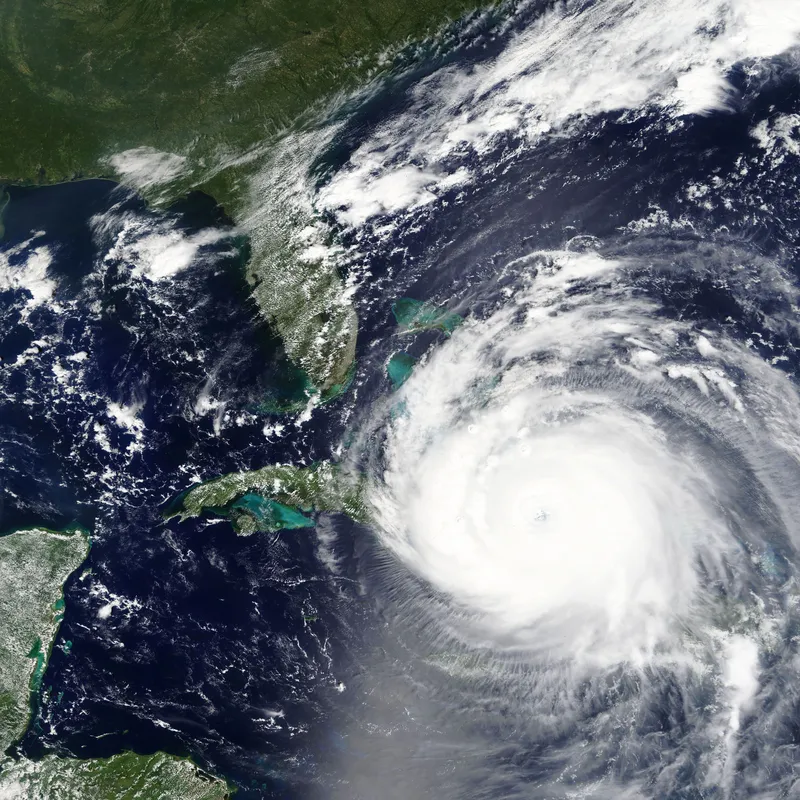
US transport authorities have put in place emergency preparations as Hurricane Idalia makes landfall in Florida.

The 125mph winds in the Category 3 storm carry a threat to life and property.

Florida Department of Transportation (FDoT) says it has opened the maximum amount of lanes possible within construction zones "to ensure mobility in impact areas".

Contractors on these construction projects were tasked with securing work sites, clearing traffic control devices that are not actively being used to direct traffic, and checking drainage systems.

Tolls have also been suspended by FDoT in facilities within the projected path of the storm.

Meanwhile, Georgia DoT says its transportation management centre is monitoring road conditions statewide as the hurricane is projected to hit several counties in the south central and south-east parts of the state.

All construction work in southern and coastal Georgia has been suspended, including everything at the I-16/I-95 interchange.

“We urge motorists to pay attention to warnings and advisories to stay off the roads due to the potential for tornadoes, extreme high winds, flash flooding and downed trees,” says Emily Fish, Georgia DoT’s assistant state maintenance engineer – emergency operations.

Motorists should be prepared to turn around when encountering water in the road and must not drive around barricades, the agency insists.

For more information on companies in this article

Related Content

  • Terrestrial solution to stellar shortcomings
    December 5, 2013
    Inherent weaknesses in satellite communications are leading several countries to re-evaluate terrestrial-based backup systems. There is a tale frequently told in satellite navigation circles, of how landing systems at Newark Airport were disrupted by a truck driver using GPS jamming equipment as he drove along the New Jersey Turnpike. While there was no threat to flight safety as the interference to GPS reference stations being tested, the story highlights how apparently benign threats have the potential t
  • Keeping cool in LA
    November 11, 2022
    As the earth’s temperatures rise, cities are set to become hotter. A project in Los Angeles may point the way to keeping cool while improving access to transit services in an uncertain future
  • Cellint measures speed and travel time without roadside infrastructure
    April 10, 2014
    Collecting speed and travel time data without using roadside infrastructure could offer new possibilities to cash-strapped road authorities. Streaming video may be useful for traffic controllers to monitor incidents and automatic number plate recognition may be required for enforcement, but neither are necessary for many ITS functions. For instance travel times, tailbacks, percentage of vehicles turning, origin and destination analysis can all be done using Bluetooth and/or WI-Fi sensors and without video o
  • New Mexico DOT launches virtual road planning
    January 8, 2013
    Planning for the road ahead is something the New Mexico Department of Transportation (DOT) takes literally, as the department oversees the planning, design, construction and maintenance of 30,000 lane miles of highways, 3,500 bridges as well as the state's transit and rail operations, while keeping costs and environmental concerns in mind during the planning stages. To assist with the development of infrastructure projects, the department will roll out cloud-based building information modeling software late