
Moovit uses riders to help get far from crowds

User-generated reports will make people feel more comfortable using public transit, firm says
By Adam Hill June 11, 2021 Read time: 2 mins
Moovit: minding the gap

Mobility as a Service specialist Moovit has added a user-generated 'crowd avoidance' feature to its app.

Designed to enable public transit riders to avoid crowds on platforms and carriages, users can "now report crowding levels at stations and on lines, allowing others to see how crowded the station is before entering, or how packed a bus or train line is before boarding", the company says. 

Moovit says most transit agencies do not provide real-time crowding information "due to no, or lack of, crowd counters installed on their fleets or at stations".

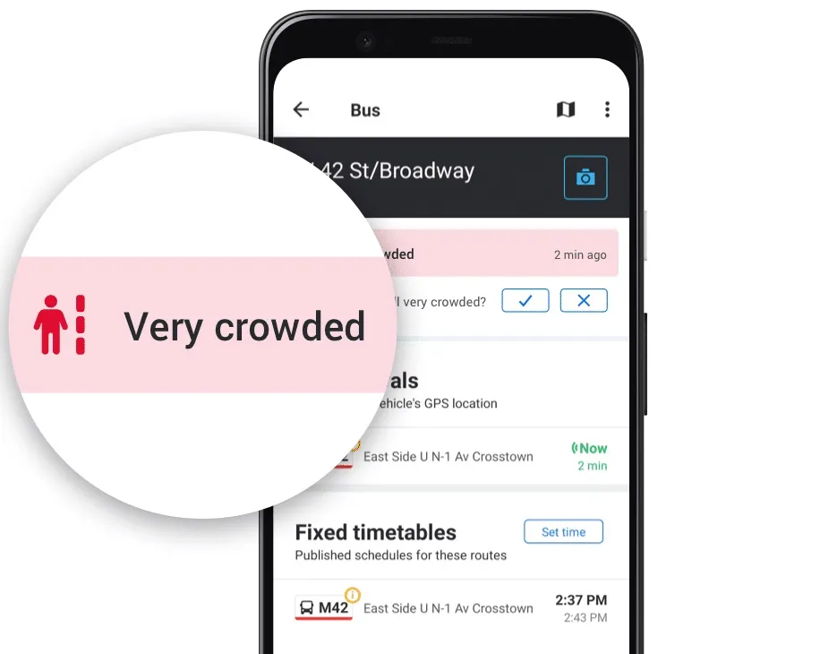
Moovit users can tap Report from the Quick Actions bar in the Station Details screen and follow the prompts and one-tap survey to report how busy the station currently is - choices are Not Crowded, A Little Crowded, Crowded or Very Crowded.

This information can be seen for 10 minutes by other users in the Station Details and Stations Nearby screens on the app.

Reporting crowding levels on buses or trains themselves is similar, with users able to select Available Seats, Standing Only, or Crowded - this data will be displayed, again in a 10-minute window - across the Suggested Routes, Itinerary, Route Preview, Stations Nearby and Station Details screens.

Other users of the Android app can also now confirm and update these user-created reports about station crowdedness.

Yovav Meydad, Moovit’s chief growth and marketing officer, says the existing Mooviter Community of more than 700,000 local 'editors', who map transit information in their cities, "has been very positive and impactful".

“We’re drawing on this belief again, empowering millions of Moovit users to help one another feel comfortable returning to public transit," Meydad says.

In cities where real-time crowding information for lines is available, Moovit will display the real-time feeds supplied by transit agencies instead of the user-reported information. 

Moovit says the app, which can be downloaded on Google Play and the App Store, is available in 3,400 cities across 112 countries.

For more information on companies in this article

Related Content

  • Santa Cruz loses contact with Masabi
    November 13, 2020
    Mobile ticketing application is expected to improve passenger safety
  • TEST Real time traffic updates
    March 15, 2013
    Motorists in Belgium can now obtain real time traffic and travel updates at selected Total fuel stations, thanks to information supplied by mobility services provider Be-Mobile displayed on screens designed and implemented by digital communications specialist Dobit. The up to the minute graphical traffic overview displays traffic jams, road works and accidents. The screens will switch views from traffic information to in-house deals for shoppers and other relevant information, which Total hopes will increa
  • New York's Metro-North Railroad to test smartphone tickets
    July 13, 2012
    The Metropolitan Transportation Authority Metro-North Railroad, working with transit mobile ticketing specialists Masabi US, will begin testing a smartphone app that will let people buy their train tickets anywhere, anytime and never have to hold a piece of paper. During the pilot, select users will be able to download the free app to their iPhone, Android or Blackberry phones. Through the app, these users can buy any type of ticket, one-way, round trip, 10-trip, monthly etc, with any origin and destination
  • New traffic service offering from Inrix
    October 28, 2013
    According to Inrix, its latest Inrix XD Traffic service covers 6.4 million kilometres of road in 37 countries and provides twice the amount of road coverage than has previously been available to automakers, transportation agencies, fleets and media worldwide. Inrix XD Traffic delivers insight into what’s happening on the road independent of the country or map provider, with features such as: detailed traffic speeds for every mile down to 250 metre increments; map independence; sophisticated analysis of