TomTom launches RoadDNA

TomTom has launched TomTom RoadDNA, a new product for vehicle localisation that will help make automated driving a reality, faster. Designed with vehicle data storage and processing limitations in mind, RoadDNA delivers highly accurate location information that can easily be integrated into the on-board system of a vehicle. RoadDNA’s propriety technology delivers a highly optimised lateral and longitudinal view of the roadway. By matching RoadDNA data with vehicle sensor data in real-time a vehicle knows
September 14, 2015 Read time: 2 mins
1692 TomTom has launched TomTom RoadDNA, a new product for vehicle localisation that will help make automated driving a reality, faster. Designed with vehicle data storage and processing limitations in mind, RoadDNA delivers highly accurate location information that can easily be integrated into the on-board system of a vehicle.

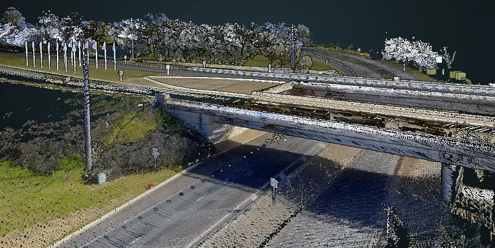
RoadDNA’s propriety technology delivers a highly optimised lateral and longitudinal view of the roadway. By matching RoadDNA data with vehicle sensor data in real-time a vehicle knows its location on the road, even while travelling at high speeds or when changes occur to the roadside.

By converting a 3D point cloud of road side patterns into a compressed, 2D view of the roadway, RoadDNA delivers a solution that needs little storage space and limits processing requirements, without losing detail. It eliminates the complexity of identifying each single roadway object, but instead creates a unique pattern of the roadway environment. This makes the technology robust and scalable.  

TomTom RoadDNA, combined with the TomTom HAD Map, delivers accurate and robust technology by providing real-time information about a vehicle’s precise location on a map whilst coping with changes in the environment.

“We know that the future of automated driving hinges on the ability of a vehicle to continuously know exactly where it is located on the road,” said Harold Goddijn, TomTom CEO. “TomTom RoadDNA is the only technology of its kind that delivers highly accurate vehicle localisation content in an efficient and cost effective way.”

Related Content

  • September 30, 2014
    TomTom and Bosch SoftTec team up on ADAS
    TomTom is to partner with Bosch to integrate its navigation technology and maps into Bosch’s advanced driver assistance systems (ADAS), enabling Bosch to develop more advanced applications including intelligent cruise control, upcoming curve alerts, and jam tail warnings. Up-to-date map and navigation data is an essential component of ADAS, providing drivers with a more detailed view of the road ahead. TomTom’s smart map making technology enables Bosch to create more accurate advanced driving application
  • June 22, 2016
    Targeted roadside advertising project uses deep learning to analyse traffic volumes
    A targeted roadside advertising project for digital signage using big data and deep learning just launched in Tokyo, Japan, by US smart data storage company Cloudian will focus on vehicle recognition and the ability to present relevant display ads by vehicle make and model. Together with Dentsu, Smart Insight Corporation, and QCT (Quanta Cloud Technology) Japan, and with support from Intel Japan, the project will conduct, at its first stage, deep learning analysis – artificial intelligence (AI) for recog
  • October 11, 2019
    Septentrio demos AV localisation tech
    Septentrio provided GPS/global navigation satellite system (GNSS) technology for computer vision supplier Artisense’s Visual Inertial Navigation System (VINS).
  • October 12, 2016
    Tomtom offers authorities sensor-free traffic monitoring
    Tomtom City, a traffic information and analytics package designed to help authorities monitor road conditions without the need for roadside infrastructure, is on display on Tomtom’s stand at this week’s ITS World Congress. The company collects data from 450 million connected devices worldwide (6% of Australian vehicles or occupants have a connected device) to determine vehicle speeds, congestion levels and incidents on most roads – and not just those in urban areas. Authorities using City can monitor traf