
Here unveils latest real-time data services for automotive industry

Location mapping specialist Here is to introduce new vehicle-sourced data services for the auto industry, enabling drivers to access this view of the road through four services that provide information on traffic conditions, potential road hazards, traffic signage and on-street parking.
September 27, 2016 Read time: 1 min

Location mapping specialist 7643 Here is to introduce new vehicle-sourced data services for the auto industry, enabling drivers to access this view of the road through four services that provide information on traffic conditions, potential road hazards, traffic signage and on-street parking.

According to Here, its Open Location Platform aims to harness real-time data generated by the on-board sensors of connected vehicles to create a live representation of the road environment.

Here will start by sourcing sensor data from vehicles manufactured by its owners Audi, BMW and Mercedes-Benz cars, with plans to later expand to include data from other automakers.

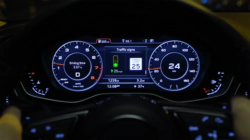
The Open Location Platform will harness the data to deliver four services, Here Real-Time Traffic; Here Hazard Warning; Here Road Signs; and Here On-Street Parking.

Here plans to make the services commercially available to any automaker, municipality, road authority, smartphone maker or app developer to licence from the first half of 2017. As connectivity and vehicle sensor technologies become more pervasive across the industry, Here also plans for other automakers to be able to contribute their vehicle data.

For more information on companies in this article

Related Content

  • Mobilising data for the future of urban transport
    August 8, 2018
    It's not just gathering the data that's important, says Johan Herrlin - it's making sure that transport organisations share it with one another that will determine travellers' satisfaction. Data is transforming the way we move around cities, from family car journeys to the daily train commute. Gone are the days when travelling from A to B meant remembering your AA map and having to ask for directions at regular intervals. If you were trying to navigate London as a tourist a mere decade ago, it required
  • Inrix informs FHWA’s data improvements
    December 19, 2017
    Refinements in the data available from the US Federal Highway Administration will improve road management across America. David Crawford reports. In August 2017, the US Federal Highway Administration (FHWA) issued the first results from an upgraded version of its National Performance Management Research Data Set (NPMRDS). Developed to identify the locations and times of high congestion affecting traffic flows along America’s 259,000km (161,000 mile) national highway system, this is a key resource for sta
  • TTS enabling drivers to see the light
    September 1, 2022
    Traffic Technology Services (TTS) is the leading provider of technologies and information supporting today’s connected vehicle applications. The company’s cloud-based platform enables increased safety and efficiency for drivers by connecting vehicles to traffic signals and other roadway infrastructure, as visitors to the company’s stand will learn. 
  • With C-ITS we can get ourselves connected
    June 27, 2025
    Workzones need to be safer for drivers and workers – and the technology exists to harmonise safety with mobility needs, says Swarco’s Daniel Lenczowski