
Q-Free and Raytheon bring MassDoT toll into focus 

Contract aimed at reducing need for manual review of images
By Adam Hill May 14, 2020 Read time: 2 mins
Q-Free works with Raytheon in Massachusetts (© Ritu Jethani | Dreamstime.com)

Q-Free has combined with sensor specialist Raytheon Intelligence & Space to improve enforcement and tolling for Massachusetts Department of Transportation (MassDoT).

MassDoT's All Electronic Tolling System (AETS) has processed more than one billion camera image tolls since its inception, but must manually review many images because of unreadable or obscured plates.

However, the Covid-19 crisis is likely to accelerate the move to cashless tolling, making accurate readings vital.

Q-Free is installing its proprietary Intrada Insight automated licence plate reading system, which the company says will reduce the need for manual inspection: Bill Rapp, executive vice president of tolling solutions for Q-Free America, called it a "progressive agreement".

“As MassDOT’s tolling partner we are always looking for new technologies to improve the system and reduce operational costs," says Matt Gilligan, Raytheon vice president.

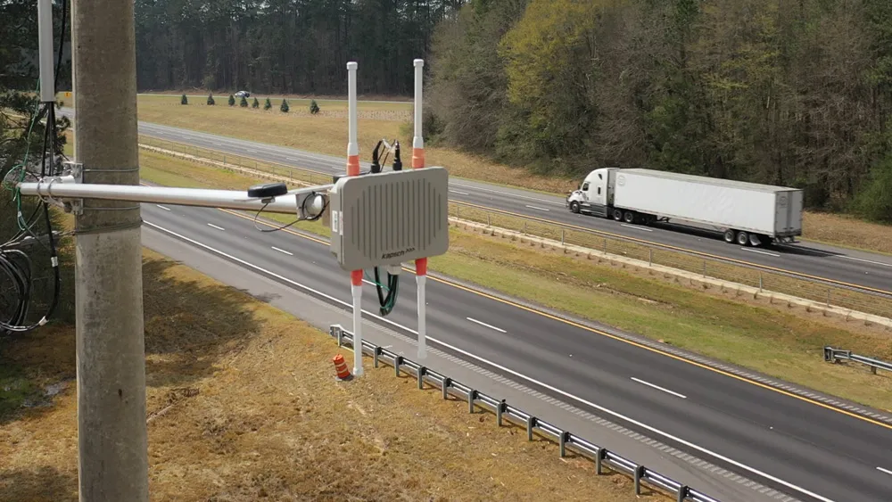
In a separate development, Q-Free has migrated its I-670 SmartLane congestion relief project in Columbus, Ohio to the cloud. Carried out with Amazon Web Services, the Ohio DoT project is one of the first of its kind to move to a cloud-hosted environment.

Q-Free says early data from the pilot scheme – which has hard shoulder running (HSR) at its heart - suggests that commute times from downtown Columbus to the east side have been halved.

The I-670 pilot uses Q-Free’s OpenTMS advanced traffic management system to provide operators with weather, speed, radar and camera data to help manage shoulder lanes and relieve congestion. 
 
“With our experience in Europe, we’ve seen how HSR can make a huge difference in relieving congestion and we brought that knowledge to this project,” said Tom Phillips, executive vice president of Q-Free’s Inter-Urban Division. “It’s a customised solution using several Q-Free OpenTMS modules to dial in the appropriate level of information at the right time.”
 

Related Content

  • Iteris adds MAP21 to performance measurement software
    June 2, 2015
    Iteris has announced it has added MAP-21 (Moving Ahead for Progress in the 21st Century) features to the robust iPeMS performance measurement software platform, designed to help agencies meet forthcoming performance reporting requirements of the transportation legislation. The module supports the National Performance Management Research Data Set (NPMRDS) that is provided free to states and Metropolitan Planning Organisations (MPOs). Iteris’ iPeMS platform provides cloud-based hosting of processed NPMRDS
  • DDOT releases draft moveDC Plan
    June 6, 2014
    The District Department of Transportation (DDOT) has released the draft moveDC Transportation Plan, a comprehensive, multimodal transportation strategy that outlines policies, programs and capital investments to enhance the District’s transportation network, and includes detailed elements or master plans for each mode of travel in the District. The plan takes into account projections that the city will add about 170,000 residents in the next 25 years, and increase jobs by 40 per cent, for an additional 2
  • Google has been testing driverless cars on open roads
    March 2, 2012
    Internet search giant Google has revealed that, in an effort to help prevent traffic accidents, free up people’s time and reduce carbon emissions by fundamentally changing car use, it has developed technology for cars that can drive themselves.
  • Panasonic gets connected on The Ray
    June 5, 2020
    A stretch of rural Georgia highway called The Ray is a particularly useful testbed for V2X technology. Panasonic’s Chris Armstrong tells Adam Hill what’s so special about it